1. 태풍의 정의와 발생 원리
태풍은 열대 지방에서 발생하는 강력한 기상 현상으로, 바람의 세기와 비가 많이 내리는 특징을 가지고 있습니다. 태풍은 해양에서 발생한 후, 열대 저기압이 발달하면서 회전하는 형태로 진화합니다. 이 회전은 지구의 코리올리 효과에 의해 발생하는데, 코리올리 효과는 지구의 자전에 의해 발생하는 힘으로, 북반구에서는 오른쪽으로, 남반구에서는 왼쪽으로 회전하는 현상입니다. 태풍은 이 회전을 통해 발생하며, 바람의 세기와 비의 양은 태풍의 강도에 따라 달라집니다. 태풍은 주로 열대 지방에서 발생하지만, 일부 경우에는 한반도와 같은 지역까지 영향을 미칠 수 있습니다. 태풍은 많은 피해를 야기할 수 있으므로, 사전에 대비하고 안전한 대처가 필요합니다.
2. 태풍의 경로 예측을 위한 기상학적 요소
태풍의 경로 예측은 매우 중요한 과제이다. 이를 위해 기상학적 요소들을 분석하고 예측 모델을 구축해야 한다. 태풍의 경로는 다양한 요소들에 의해 결정되는데, 주로 태풍의 위치, 기압, 바람의 방향과 세기, 해수면 온도 등이 영향을 미친다. 이러한 요소들을 고려하여 태풍의 경로를 예측하는 모델을 개발하고, 이를 통해 사전에 대비할 수 있는 시간을 확보하는 것이 중요하다. 또한, 태풍의 경로 예측은 인간의 생명과 재산을 보호하는데 큰 역할을 한다. 따라서, 기상학적 요소들을 철저히 분석하고 예측 모델을 개발하여 태풍의 경로 예측 정확도를 높이는 것이 필요하다.
3. 태풍의 강도 측정과 분류 기준
태풍은 강한 바람과 폭우를 동반한 자연재해로, 많은 피해를 야기할 수 있습니다. 따라서 태풍의 강도를 정확히 측정하고 분류하는 것은 매우 중요합니다. 태풍의 강도는 일반적으로 바람의 세기를 기준으로 측정됩니다. 바람의 세기는 풍속계를 사용하여 측정되며, 일반적으로 초속으로 표시됩니다. 태풍의 강도는 일반적으로 1부터 5까지의 등급으로 분류됩니다. 등급이 높을수록 태풍의 강도가 강해지며, 피해 가능성도 높아집니다. 태풍의 강도 측정과 분류 기준은 국제 기상기구(WMO)에서 제정한 기준을 따릅니다. 이 기준은 바람의 세기뿐만 아니라 태풍의 중심 기압, 평균 풍속 등을 고려하여 태풍의 강도를 판단합니다. 이러한 강도 측정과 분류 기준을 통해 태풍에 대한 경보 및 대비 조치를 적절히 취할 수 있습니다.
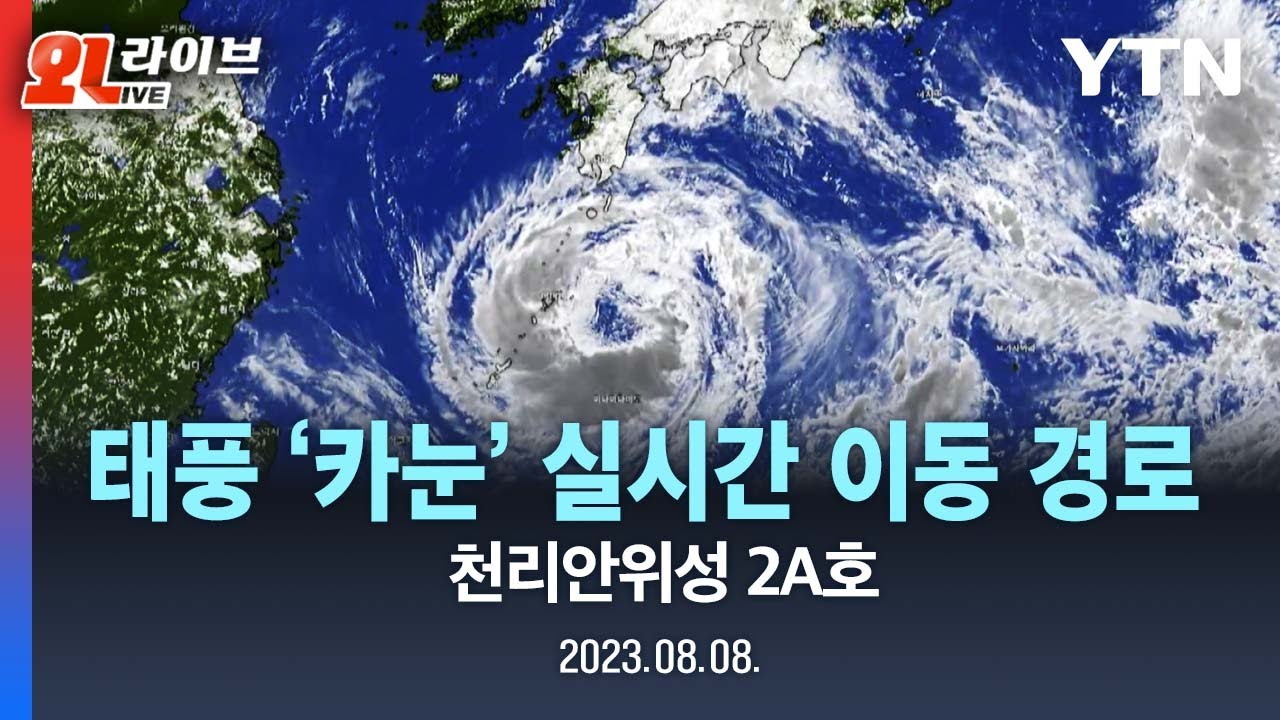
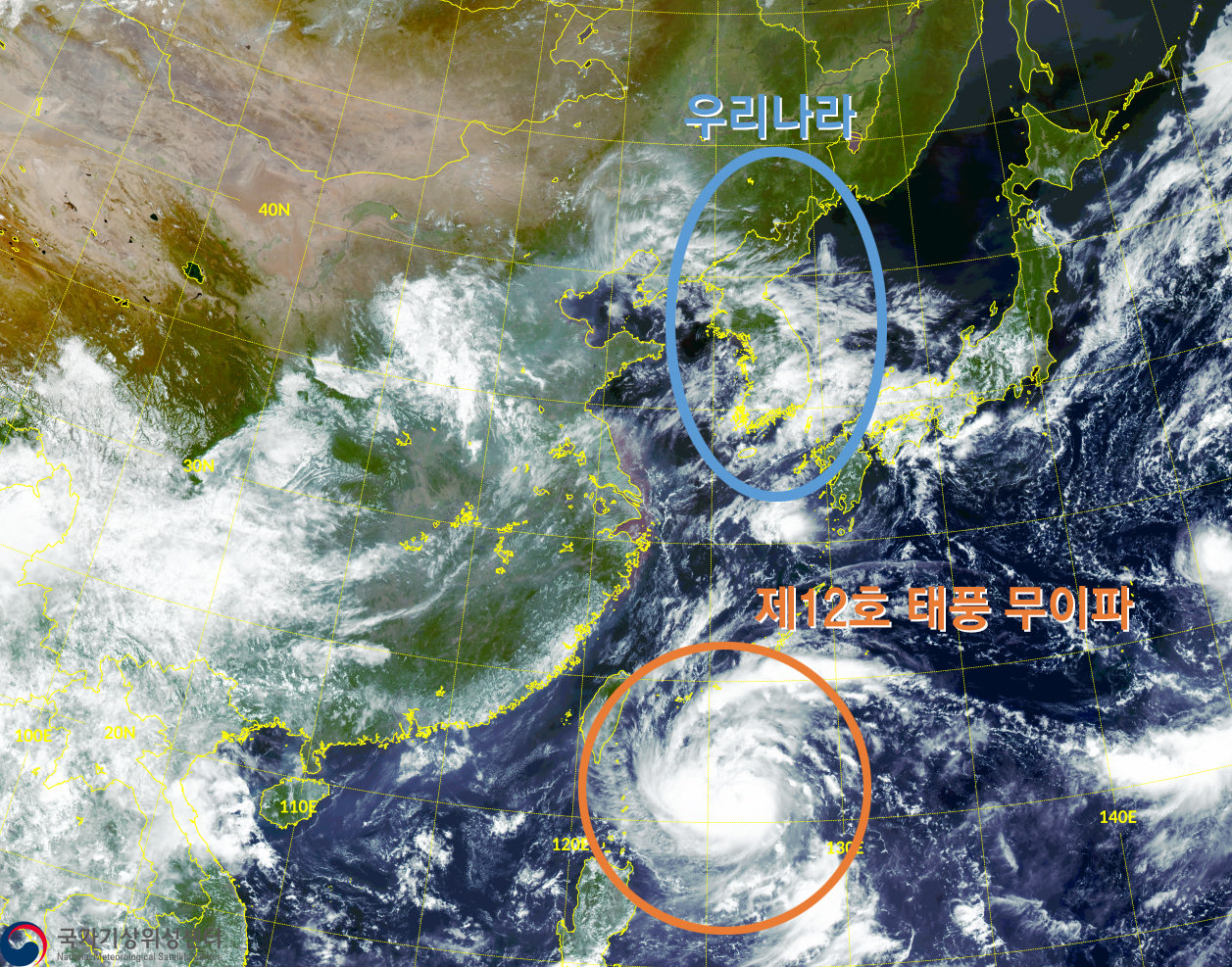
4. 태풍 경로 추적을 위한 기상 위성과 레이더 시스템
태풍 경로 추적을 위해 기상 위성과 레이더 시스템은 매우 중요한 역할을 합니다. 기상 위성은 대기 상태를 실시간으로 모니터링하여 태풍의 위치와 크기를 파악하는 데 도움을 줍니다. 이를 통해 태풍의 이동 경로를 예측하고 대비 조치를 취할 수 있습니다.
또한 레이더 시스템은 기상 조건을 측정하고 태풍의 위치와 강도를 정확하게 파악하는 데 사용됩니다. 레이더는 전자기파를 발사하여 그 신호를 태풍에 반사시킴으로써 태풍의 위치와 강도를 측정합니다. 이를 통해 태풍의 이동 경로와 예상 도달 시간을 예측할 수 있습니다.
기상 위성과 레이더 시스템은 태풍 경로 추적에 있어서 필수적인 장비로 알려져 있습니다. 이들의 데이터를 실시간으로 분석하고 해석함으로써 태풍으로 인한 피해를 최소화할 수 있습니다. 따라서 태풍 예보 및 대비에 있어서 이들의 활용은 매우 중요합니다.
5. 태풍 경로 추적의 중요성과 예방 대책
태풍은 매년 여러 지역에서 큰 피해를 야기하는 자연재해 중 하나입니다. 태풍이 발생하면 많은 사람들이 피해를 입고, 재산이 파괴되며, 인명 피해도 발생합니다. 이러한 이유로 태풍의 경로 추적은 매우 중요합니다.
태풍의 경로 추적은 기상청과 관련 기관들이 주로 담당하고 있습니다. 기상청은 태풍의 발생과 이동 경로를 예측하여 관련 정보를 제공합니다. 이를 통해 주민들은 태풍의 도래를 미리 예측하고 대비할 수 있습니다.
태풍의 예방 대책은 다양한 형태로 이루어집니다. 가장 기본적인 예방 방법은 태풍이 다가올 때 안전한 장소로 대피하는 것입니다. 또한, 주변 환경을 정리하고, 외부에서 날아오는 물체나 나무 등을 고정시키는 등의 조치도 필요합니다.
또한, 태풍에 대비하여 비상 대피 계획을 수립하는 것도 중요합니다. 대피 경로와 대피 시설을 미리 파악하고, 가족 구성원들과 소통하여 대피 계획을 공유하는 것이 좋습니다.
마지막으로, 태풍에 대비하여 생활용품과 식량 등을 미리 준비하는 것도 필요합니다. 긴급 상황에 대비하여 충분한 양의 식량과 생활용
#태풍, #기상현상, #바람, #비, #열대저기압, #회전, #코리올리효과, #강도, #영향, #대비, #경로예측, #기상학적요소, #예측모델, #위치, #기압, #바람방향, #바람세기, #해수면온도, #생명, #재산, #강도측정, #분류, #풍속계, #등급, #중심기압, #평균풍속, #기준, #기상위성, #레이더시스템
1. Definition of typhoon and how it occurs
A typhoon is a powerful weather phenomenon that occurs in tropical regions and is characterized by strong winds and heavy rain. Typhoons originate in the ocean and then evolve into a rotating form as tropical cyclones develop. This rotation is caused by the Earth's Coriolis effect, which is a force generated by the Earth's rotation, causing it to rotate to the right in the Northern Hemisphere and to the left in the Southern Hemisphere. Typhoons are formed through this rotation, and the wind strength and amount of rain vary depending on the intensity of the typhoon. Typhoons mainly occur in tropical regions, but in some cases they can affect areas such as the Korean Peninsula. Typhoons can cause a lot of damage, so you need to prepare in advance and respond safely.
2. Meteorological factors for predicting the path of a typhoon
Predicting the path of a typhoon is a very important task. For this purpose, meteorological factors must be analyzed and a prediction model must be built. The path of a typhoon is determined by various factors, mainly the location of the typhoon, atmospheric pressure, wind direction and strength, and sea surface temperature. It is important to develop a model that predicts the path of a typhoon by considering these factors and thereby secure time to prepare in advance. Additionally, predicting the path of a typhoon plays a major role in protecting human life and property. Therefore, it is necessary to thoroughly analyze meteorological factors and develop a forecast model to improve the accuracy of predicting the path of a typhoon.
3. Typhoon intensity measurement and classification criteria
A typhoon is a natural disaster accompanied by strong winds and heavy rain and can cause a lot of damage. Therefore, it is very important to accurately measure and classify the intensity of typhoons. The intensity of a typhoon is usually measured based on wind strength. Wind strength is measured using an anemometer and is usually expressed in speed per second. Typhoon intensity is generally classified on a scale from 1 to 5. The higher the grade, the stronger the typhoon and the greater the potential for damage. Typhoon intensity measurement and classification standards follow the standards established by the International Meteorological Organization (WMO). This standard determines the intensity of a typhoon by considering not only the wind strength, but also the typhoon's central pressure and average wind speed. These intensity measurements and classification criteria allow appropriate warning and preparedness measures for typhoons.
4. Meteorological satellite and radar system for tracking typhoon paths
Meteorological satellites and radar systems play a very important role in tracking typhoon paths. Meteorological satellites monitor atmospheric conditions in real time to help determine the location and size of typhoons. This allows you to predict the typhoon's path and take preparedness measures.
Radar systems are also used to measure weather conditions and pinpoint the location and intensity of typhoons. Radar measures the location and intensity of a typhoon by emitting electromagnetic waves and reflecting the signals back to the typhoon. This allows you to predict the typhoon's path and expected arrival time.
Meteorological satellites and radar systems are known to be essential equipment in tracking typhoon paths. Damage from typhoons can be minimized by analyzing and interpreting their data in real time. Therefore, their use is very important in typhoon forecasting and preparation.
5. Importance of tracking typhoon paths and preventive measures
Typhoons are one of the natural disasters that cause great damage to many regions every year. When a typhoon occurs, many people are affected, property is destroyed, and lives are lost. For this reason, tracking the path of typhoons is very important.
The Korea Meteorological Administration and related organizations are mainly responsible for tracking the path of typhoons. The Korea Meteorological Administration predicts the occurrence and movement path of typhoons and provides related information. This allows residents to predict and prepare for the arrival of typhoons.
Typhoon prevention measures come in various forms. The most basic prevention method is to evacuate to a safe place when a typhoon approaches. In addition, measures such as cleaning up the surrounding environment and fixing objects or trees flying in from outside are also necessary.
It is also important to have an emergency evacuation plan in case of a typhoon. It is a good idea to identify evacuation routes and evacuation facilities in advance, and communicate with family members to share your evacuation plan.
Lastly, it is also necessary to prepare daily necessities and food in advance in preparation for a typhoon. Sufficient food and living supplies for emergencies
#Typhoon, #Meteorological phenomenon, #Wind, #Rain, #Tropical cyclone, #Rotation, #Coriolis effect, #Intensity, #Impact, #Contrast, #Path forecast, #Meteorological factors, #Forecast model, #Location, # Atmospheric pressure, #wind direction, #wind strength, #sea surface temperature, #life, #property, #intensity measurement, #classification, #anemometer, #class, #central pressure, #average wind speed, #standard, #meteorological satellite, #radar system
1. 台風の定義と発生原理
台風は熱帯地方で発生する強力な気象現象で、風の強さと雨の多い特徴を持っています。台風は海洋で発生した後、熱帯低気圧が発達しながら回転する形に進化します。この回転は地球のコリオリ効果によって発生し、コリオリ効果は地球の自転によって発生する力で、北半球では右に、南半球では左に回転する現象です。台風はこの回転によって発生し、風の強さと雨の量は台風の強さに依存します。台風は主に熱帯地域で発生しますが、場合によっては朝鮮半島などの地域に影響を与える可能性があります。台風は多くの被害を引き起こす可能性があるため、事前に備えて安全な対処が必要です。
2.台風の経路予測のための気象学的要素
台風のルート予測は非常に重要な課題です。そのためには、気象学的要素を分析し、予測モデルを構築する必要があります。台風の経路は様々な要因によって決まり、主に台風の位置、気圧、風の方向と強度、海面温度などが影響します。これらの要因を考慮して台風の経路を予測するモデルを開発し、これにより事前に備えられる時間を確保することが重要である。さらに、台風の経路予測は、人間の生命と財産を保護するのに大きな役割を果たします。したがって、気象要素を徹底的に分析し、予測モデルを開発して台風の経路予測精度を高めることが必要です。
3. 台風の強度測定と分類基準
台風は強い風と大雨を伴う自然災害で、多くの被害を引き起こす可能性があります。したがって、台風の強度を正確に測定して分類することは非常に重要です。台風の強さは、一般的に風の強さに基づいて測定されます。風の強さは風速計を使用して測定され、通常は秒速で表されます。台風の強さは一般的に1から5までのグレードに分類されます。等級が高いほど台風の強さが強くなり、被害の可能性も高くなります。台風の強度測定と分類基準は、国際気象機関(WMO)によって制定された基準に従います。この基準は、風の強さだけでなく、台風の中心気圧、平均風速などを考慮して台風の強さを判断します。これらの強度測定と分類基準により、台風の警報やコントラスト対策を適切に取ることができます。
4.台風経路追跡のための気象衛星とレーダーシステム
台風経路を追跡するために、気象衛星とレーダーシステムは非常に重要な役割を果たします。気象衛星はリアルタイムで大気状態を監視し、台風の位置と大きさを特定するのに役立ちます。これにより、台風の移動経路を予測し、コントラストを取ることができます。
さらに、レーダーシステムは、天候条件を測定し、台風の位置と強度を正確に把握するために使用されます。レーダーは、電磁波を発射し、その信号を台風に反射させ、台風の位置と強度を測定します。これにより、台風の移動経路と予想到達時間を予測することができます。
気象衛星とレーダーシステムは台風経路の追跡に不可欠な機器として知られています。これらのデータをリアルタイムで分析して解釈することで、台風による被害を最小限に抑えることができます。したがって、台風予報やコントラストにおけるこれらの活用は非常に重要です。
5. 台風経路追跡の重要性と予防対策
台風は、毎年さまざまな地域で大きな被害を引き起こす自然災害の1つです。台風が発生すると多くの人が被害を受け、財産が破壊され、人命被害も発生します。このため、台風のルート追跡は非常に重要です。
台風の経路追跡は、気象庁や関連機関が主に担当しています。気象庁は台風の発生と移動経路を予測し、関連情報を提供します。これにより、住民は台風の到来を事前に予測して準備することができます。
台風の予防対策は様々な形で行われます。最も基本的な予防方法は、台風が近づくときに安全な場所に避難することです。また、周辺環境を整理し、外部から飛ぶ物や木などを固定するなどの措置も必要です。
また、台風に備えて緊急避難計画を策定することも重要です。避難経路と避難施設を事前に把握し、家族のメンバーと交流して避難計画を共有することをお勧めします。
最後に、台風に備えて生活用品や食料などを事前に準備することも必要です。緊急事態に備えて、十分な量の食料と生活用
#台風、#気象現象、#風、#雨、#熱帯低気圧、#回転、#コリオリ効果、#強度、#影響、#コントラスト、#パス予測、#気象学的要素、#予測モデル、#位置、#気圧、#風の方向、#風の強さ、#海面温度、#生命、#財産、#強度測定、#分類、#風速計、#グレード、#中心気圧、#平均風速、#基準、#気象衛星、#レーダーシステム

'잡학다식' 카테고리의 다른 글
| 태풍의 위험성과 대비 방법 (2) | 2023.10.15 |
|---|---|
| 태풍의 정의와 기상 현상 설명 (0) | 2023.10.14 |
| 태풍의 정의와 발생 원리 (0) | 2023.10.12 |
| 태풍의 정의와 발생 원리 (1) | 2023.10.11 |
| 태풍의 정의와 발생 원리 (1) | 2023.10.10 |


